Astro*Carto*Graphy Settings
A*C*G is not available in the Lite or Pro versions of ZET.
The A*C*G Settings window is opened by:
- clicking the
 "Settings" Toolbar button
and selecting the "Astro*Carto*Graphy Settings..." menu item, or
"Settings" Toolbar button
and selecting the "Astro*Carto*Graphy Settings..." menu item, or
- selecting "Settings" | "Astro*Carto*Graphy Settings..." from the main menu, or
- right-clicking in the Geographical Map tableau and selecting "Astro*Cartography*Settings..." from the popup menu.
The Planets tab
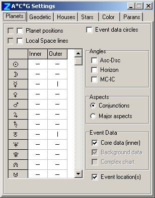
Selection of planets for display in astrocartography is separate from their selection for horoscopes. Selection for A*C*G is made on this tab by clicking to select or deselect planets, asteroid, Arabic Parts, etc in the list-box grid. Selections can also be made by clicking in the gray header and row label cells.
- Planet positions - displays a projection of the selected planets' positions onto the geographical map. The checkbox at left is enabled for dual charts only, and displays projections of the background data (outer ring) planets. The meridians at these points on the map indicate places at which the planets are on the zenith at the moment of interest (real horizontal projection),
- Local Space lines - displays lines on the geographical map indicating directions to the selected planets (i.e. direct bearings) from the event data location(s). The checkbox at left is enabled for dual charts only, and displays Local Space lines for the background data (outer ring) planets.
- Event data circles - displays strips +-1 degree (+-60 miles) wide marking the horizon and the meridian of the current event data locations,
- Horizon - displays lines indicating places where the selected planets are rising or setting on the terrestrial eastern or western horizon,
- Meridian - displays lines indicating places where the selected planets happen to be transiting the zenith or nadir.
- Asc-Dsc - displays lines indicating where the selected planets are in astrological aspect to the Asc-Desc chart axis,
- MC-IC - displays lines indicating where the selected planets are in astrological aspect to the MC-IC chart axis.
NOTE: the options of the In Mundo and Angles panels are linked. It is not possible to select both "Horizon" and "Asc-Dsc", or "Meridian" and "MC/IC".
Aspects panel - select to display:- Conjunctions - the conjunctions only of planets with the items selected on the In Mundo and Angles panels, or
- Major aspects - all major aspects of planets with the natal chart's angles. NOTE: this option is not available for In Mundo aspects.
- Core data (inner) - displays/hides A*C*G data for natal or horary charts, or the inner ring (core data) of dual and complex type charts,
- Background data - (enabled only when the chart is a dual/complex type) displays/hides A*C*G data for the outer ring (background data) of dual chart types, or for the second aspecting ring of complex type charts,
- Complex chart - (enabled only when the chart is a complex type) displays/hides A*C*G data for all rings of the chart. The display control of A*C*G information for each ring uses settings on the Complex Chart Planet Filter of the Chart Settings - Miscellanea tab.
Event location(s) - marks the geographical coordinates(s) of the event data on the map: red spot for core data, blue spot for background data,
The Geodetic tab
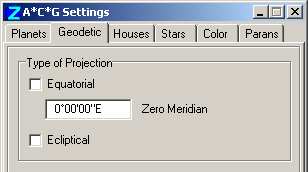
Here you can choose to display alternative symbolic projections of your selected planets.
Equatorial - meridian lines drawn where the celestial longitude of planets (in equatorial coordinates) maps to geographical longitude,
The Zero Meridian value defines the origin for this correspondence. The default is Greenwich, but you can enter any desired value e.g. the longitude of the Great Pyramid of Giza: 31°08'0.8" East.
Ecliptical - great circle lines drawn where the celestial longitude of planets (in equatorial coordinates) maps to geographical longitude. The circles drawn conform to the obliquity of the equator to the ecliptic at the time of the event data. See also Astrocartographical displays.
The Houses tab
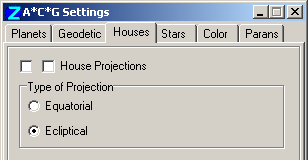
Here you can select to display projections of the astrological houses, i.e. lines of projection of the great circles of the house cusps onto the surface of the Earth. (For celestial circles of houses, see Sky). The checkbox at left is enabled for dual charts only, and displays projections of the background data (outer ring) planets.
The Equatorial option displays the lines as perpendicular to the terrestrial equator. The Ecliptical option displays them perpendicular to the ecliptic.
The Stars tab
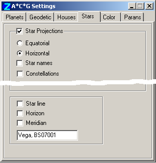
The upper panel controls the mass display of stars on the Map tableau:
- Star Projections - check this box to display symbolic or real projections of stars on the geographical map,
- Equatorial projection - displays a symbolic transformation of the equatorial coordinates of stars to geographical coordinates,
- Horizontal projection - displays a real projection of stars to geographical coordinates,
- Star Names - displays star names in addition to star marks,
- Constellations - displays constellation lines in the terrestrial projection.
The lower panel controls the display of A*C*G lines for a select individual star:
- Star line - displays for one star a line of points having the same zodiac longitude
as the given star (but different zodiac latitude).
The line is interpreted as a zone of influence of this star on Earth regions.
- Horizon - displays a line of places where the selected star is rising or setting on the terrestrial eastern or western horizon,
- Meridian - displays a line indicating where the selected star happens to be transiting the zenith or nadir.
To select a star, position the mouse pointer over a star projection on the Geographical Map, invoke the popup meu (right-button mouse click), and select the item "Select Star [star name]". The star selected is shown by name and designation at the bottom of the Stars tab.
The Color tab
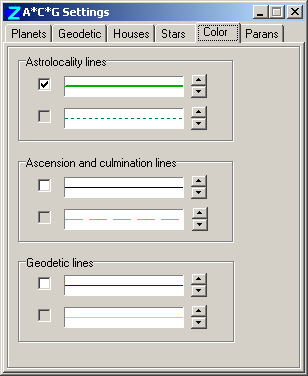
Use this tab to set the colors and styles of lines of astrolocality, ascension and culmination, and geodetics, for the core and background data planets. Here you can set the mode of coloring - either a common color for all the planets, or individual planet colors. (Individual planet colors are set on the Chart Settings - Planets tab).
- To select individual color mode, check ON the required checkboxes,
- To select common color mode, check OFF the appropriate checkboxes and click the mouse on the color panel to open a Color picker dialog.
Additionally a color it is possible to select the style of A*C*G lines: solid with some thickness, dotted or dashed (use rightmost buttons).
The selection boxes are paired. The upper boxes pertains to core data, the lower boxes to background data.
The Parans tab
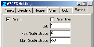
A paran is a point of intersection of two projection lines, e.g. a planet is in paran with a star if they rise, set or culminate at the same time.
A paran line is a horizontal line on the map, drawn over the paran point having a latitude equal to the paran.
To obtain a list of parans for the latitude of a specific city,
within range of the set orb:
- position the mouse pointer over the city on the geographical map,
- right-click with the mouse to invoke the map's popup menu,
- select the "Parans List [city]" menu item.
The following is an example of a parans list:
Parans within 1° of London
...
51n34 Neptune(Set)-Aldebaran(IC)
51n32 Neptune(Set)-Antares(MC)
51n32 Antares(Rise)-Venus(MC)
51n30 London
51n14 Arcturus(Set)-Sun(IC)
51n13 Pluto(Set)-Moon(MC)
51n10 Vega(Set)-Saturn(MC)
50n50 Saturn(Set)-Arcturus(Set)
...
Explanation: the line "Antares(Rise)-Venus(MC)" means that at this time there is a paran formed between the star Antares rising and Venus culminating.
The Orb entryfield allows you to set a criterion for list inclusion. Setting the Max. North latitude and Max. South latitude entryfields allows you to reduce the list to candidates of interest.
In calculating this list, ZET considers selected planets (Planets tab of A*C*G Settings window) and all filtered stars.